Posts
French Broad River Watershed Flood Plain Map
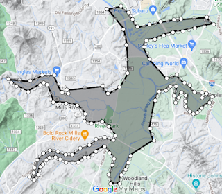
Since the French Broad River Watershed is fairly large, I chose to highlight a smaller area of the floodplains in the watershed. 15 miles South of Asheville, NC lies Mills River, NC. Compared to the mountains surrounding Mills River, NC, the town has a flat and lower elevation, which puts it at risk for flooding. Over the next 30 years, 446 properties in Mills River have greater than a 26% chance of being affected by flooding. Sources: Risk Factor. (n.d.). Does Mills River have Flood Risk? . riskfactor.com. https://riskfactor.com/city/mills-river-nc/3743260_fsid/flood